Omaha Beach - Vierville Draw


The western half of Omaha Beach was assigned to the 116th RCT of the 29th Infantry Division, a National Guard unit from Virginia and Maryland with additional troops from other parts of the US.  Vierville Draw was the westernmost of the five beach exits necessary to bring follow-on troops and equipment inland.  With a good hard-surface road, Vierville Draw was the best of the beach exits.  The invasion plan was to attack these exits directly, with the hope of a quick and easy capture with minimal casualties.  An air attack from heavy bombers along with a naval bombardment was supposed to leave any surviving German defenders dazed and confused.  In reality, the naval bombardment was short and largely ineffective against German defenses which were well hidden and often positioned to rake the beach with little exposure from the sea side.  The heavy bomber bombardment was even more disappointing.  With low visibility in the early morning, and with the bombers approaching directly across the beach instead of along it, the airmen released their bombs late for fear of killing the men approaching the beach in landing craft.  The bombs fell on empty farmland far inland, leaving the beach defenses untouched.  The landing craft had been loaded and launched ten miles out due to concerns of German artillery.  Low, early morning, visibility hindered the men steering the landing craft ashore, which, combined with rough seas and strong currents, meant that many units would go ashore in the wrong places.  Rough seas also played havoc with two battalions of duplex drive tanks, tanks with canvas screens for floatation and propellors for propulsion.  With the duplex drive tanks largely out of action, conventional Sherman tanks landed from landing craft were left to carry the load.  While the British developed and used specialized tanks, 'funnies', for things like mine clearing or flame throwing, the Americans refused a British offer to loan some of the vehicles.


Vierville Draw

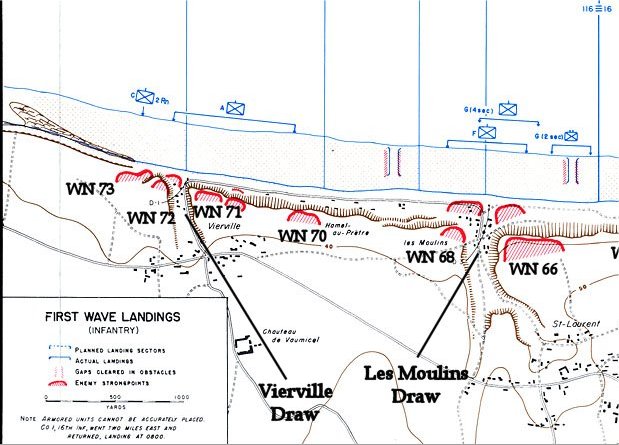
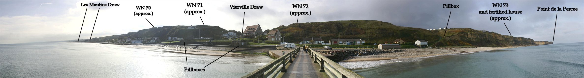
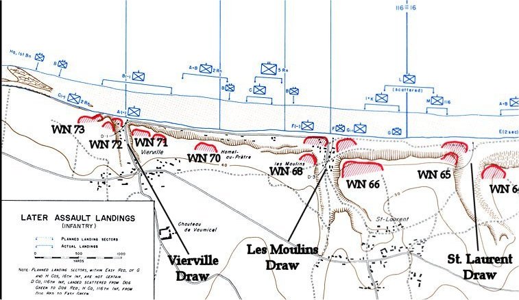
This is the view from a post-war pier off of Vierville Draw.  High tide is shown here, which is not hisorical.  The date and time of the invasion was set for the lowest possible tide, so that German beach obstacle would all be above water and of little threat to the landing craft.  At the time of the initial landings, about 6:30am, the waterline was approximately 300 to 400 yards out.  The invasion plan was for Company C of the 2nd Rangers to land to the right of the draw in two LCAs.  Company A of the 116th would land from six LCAs with three boats on either side of the draw.  To the left of Co A, it was intended that Companies G, F, and E of the 116th would simulataneously land on the next mile of beach and advance inland along with Co A and the 743rd Tank Bn.  In reality, poor visibility from brush fires (caused by the bombardment) along with strong currents took Companies G, F, and E far off course.  Co E was a full mile off course and fought with the 1st Division.  Companies F and G landed near Les Moulins Draw, the next beach exit.  This left Co A, 116th and Co. C, 2nd Rangers to attack Vierville Draw alone.  Bad luck continued as one of the six boats transporting Co A sprung a leak and sank, resulting in one man drowning and the rest of the men struggling to stay afloat before being rescued.  The remaing five boats continued on and beached.


The bow ramps dropped, and the men began to exit single file and advance through the surf to the beach.  Although the men had been told that the naval and air bombarments would make them witnesses to 'the greatest show on earth', there was no damage to speak of.  German defenses appeared untouched, and there were no shell craters.  A few Sherman tanks were to their left.  In front was an assortment of beach obstacle, then behind a wall 9 feet high and 125 feet long, were two German pillboxes, strangley silent.  Were they manned?  Bursts of machine gun fire from the pillboxes soon answered the question.  The Germans had waited until all the Americans were off the boats and vulnerable.  It was a slaughter.  Of the 155 men who landed with Co A, 116th, 91 were killed that day, and most of the rest were wounded, all but 15.  Nineteen of the dead were from Bedford, Virginia, including two brothers, Raymond and Bedford Hoback.  Cpt Taylor Fellers of Bedford and every one of the men who came ashore from his boat was killed.  Co A's survivors fell back to the surf, behind obstacles, or behind the tanks.

Meanwhile, the 65 men of Co C, 2nd Rangers, in two boats, under Cpt Ralph Goranson had had their own troubles.  The original plan was for the Rangers to shift left, or east, along the beach, then pass through Vierville Draw which was to have been captured by the 116th Regiment.  The Rangers would then capture a German strongpoint at Point de la Percee from the landward side.  On the way in, the men were singing in the boats on account that June 6th was one of the men's wedding anniversary.  The singing stopped, however, when the Germans opened fire with an 88mm gun, hitting one of the LCAs and causing 12 casualties before the boats even landed.  Once beached, the Rangers hurried across the beach through German fire to the foot of the cliffs.  Only about 30 of the original 65 Rangers made it to the cliffs.  Seeing the disaster that had befallen Co A, 116th, it was time for a new plan.  Shifting about 300 yards westward, or right, along the cliffs, they began to climb, hoping to reach the top and take the German positions from the rear.  Goranson himself nearly became a casulty from a grenade thrown from atop the cliff.  Unlike the Rangers at Point du Hoc, Goranson's men lacked climbing equipment, but they were able to ascend the 100 foor cliffs with bayonets and toggle rope. 


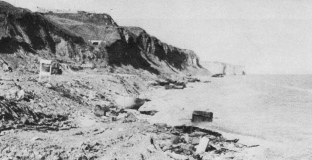
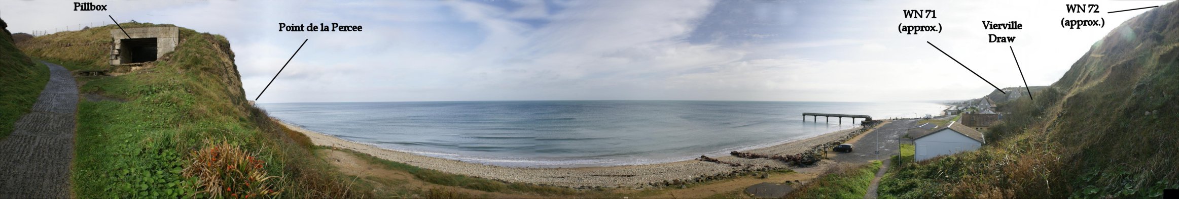
 Wartime view down the beach toward where Goranson's men went ashore and climbed the cliffs.  The pillbox enfilading the beach, still extant, is prominent.


   At around 7:15, the second wave began to approach the beach - Companies B and D in twelve LCAs and 1st Bn HQ and medics in three LCAs.  By the time they saw that the first wave was shattered, it was too late to divert to another beach.  In the boat carrying Cpt. Zappacosta of Co. B, only one man survived the landing.  In another boat, an 88mm round came through, destroying the ramp, destroying the doors while killing Cpt Schilling, the CO of Company D and blinding the platoon sergeant.  Like the first wave, the second wave took heavy casualties and were pinned down.  Company D, 116th had 5 of its 9 officers killed and 10 sergeants killed.  One of the survivoring sergeants of Co. D, Robert Slaughter of Bedford, Virginia many decades later would spearhead efforts to get the National D-Day Memorial built in Bedford.  He later write a book about his wartime experiences.  (Co. D is not shown on the map for some reason.)  Three LCAs with Co. B men successfully diverted 1,000 yards further east. 


Cliffs to the West of Vierville Draw

By 7:15, about when the second wave was landing, Goranson himself had climbed the cliffs.  This may have been in the notch shown here.  (see wartime photo below)  Goranson soon made the decision to move east to capture the defenses around Vierville.  Lt. William Moody and six Rangers found the 'fortified house' along the cliff unoccupied but heard Germans just beyond it in WN 73.  Moody was soon killed by sniper fire, but more Rangers arrived, and they captured the German strongpoint.  A boat team from Co. B, 116th assisted the Rangers.  The men here had done a great deal to make Vierville Draw safe.  

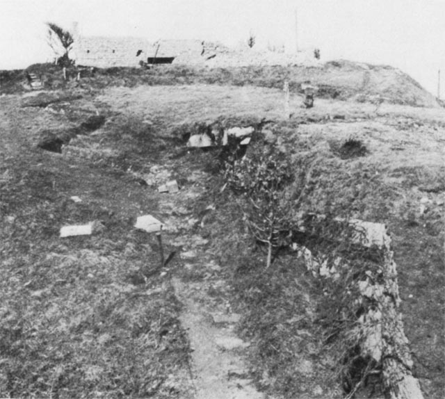
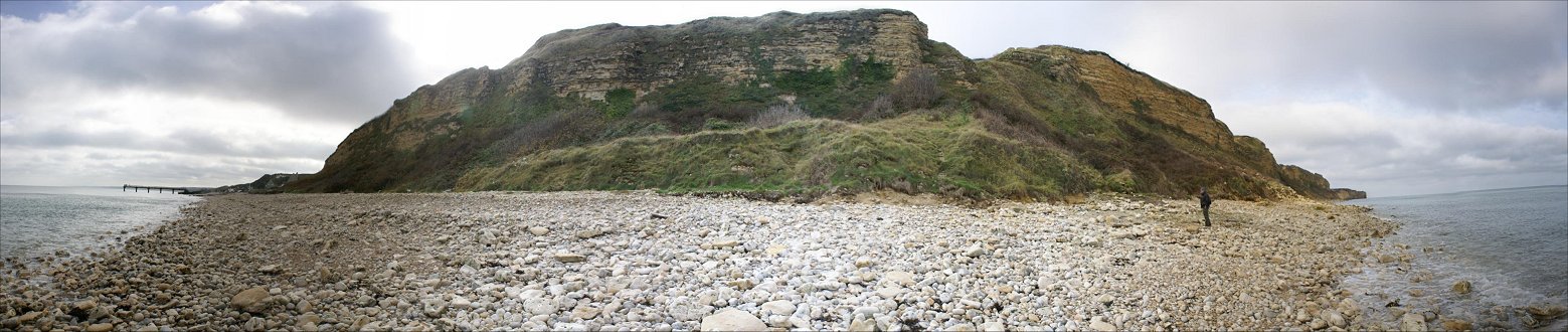
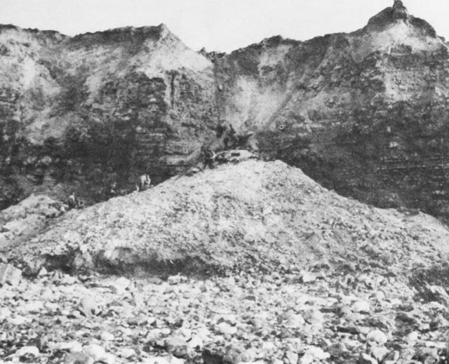
Where Goranson's Company Scaled the cliff Fortified House


View From Atop the German Pillboxes


The Eastern of the Two Beach Pillboxes


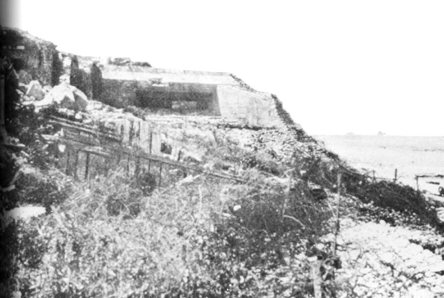
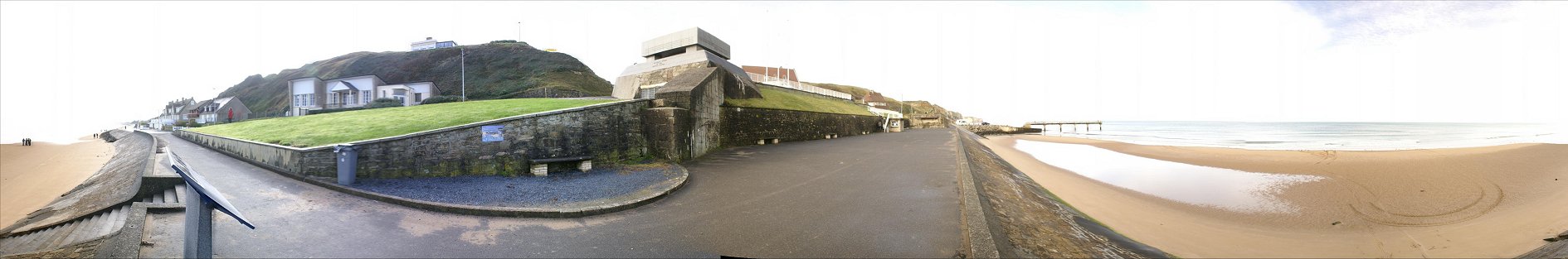
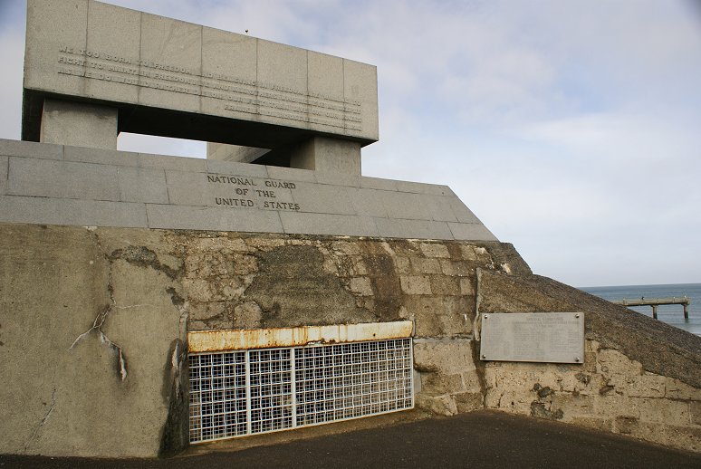
The pillbox was camoflauged to look like beach house from the front.  Note all the wire in front of it. The pillbox is now a monument to the National Guard.


The pillbox at left was positioned to fire along the beach, making it especially dangerous to landing troops.


This is the view from a little further up the bluff.  The pillbox is the flat area in the lower left-center of the photo.


Zoom view.


Copyright 2010 by John Hamill


Back to Omaha Beach

Continue to Les Moulins Draw